July 2025 was 12th warmest month on record - Met Éireann


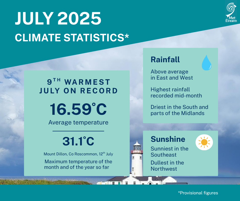
July 2025 was the ninth warmest July and 12th warmest of any month in 126 years of records, according to Met Éireann's Climate Statement for July 2025.
The month had an average temperature of 16.59°C, which is 1.74°C above the 1961-1990 long-term average (LTA) for July and 1.21°C above the more recent 1991-2020 LTA.
A build-up of the Azores high over Ireland resulted in plenty of sunshine and a hot spell from July 10 to 13, in which temperatures surpassed 27°C on each day.
Rainfall was unevenly distributed across the country during the month, with levels well above average in parts of the east and west, and well below average in parts of the south and north midlands.
Continuing the recent warmer-than-normal monthly trend, this is the fifth consecutive month with temperatures in the respective top nine averages on record in 126 years of records.
Of the top 10 warmest July’s, five have occurred since 2001 (2013, 2006, 2021, 2025, 2018).
July 2025 observed an average of 96mm rainfall, which is slightly above average at 103% of the 1991-2020 LTA, the wettest July since 2023 and 33rd wettest overall since 1941.
July 2025 was warm with close to average rainfall overall. High pressure to the south and low pressure to the north brought a predominantly westerly airflow.
The first week began relatively cool with high pressure to the south in control. By mid-week, a low-pressure system to the north brought frontal rain and introduced a warmer airmass across the country, according to the climate statement.
Toward the end of the week, high pressure in the south-west began to build northward once again.
The second week saw the Azores high building north over the country bringing lots of sunshine and increasing temperatures.
This culminated in a hot spell, where temperatures surpassed 27°C on each day between Thursday 10 and Sunday 13. A thundery breakdown followed late on Sunday 13 and through the day on Monday 14 as low pressure began to push in from the Atlantic.
The third week saw slow-moving low pressure systems meandering close to or over Ireland with frontal rain and/or heavy thundery downpours affecting different parts of the country each day.
An active weather front stalled over the eastern half of the country on Monday 21, bringing a prolonged spell of heavy rainfall to parts of the east.
The fourth week was drier as high pressure built to the south again. Low pressure to the north continued to steer weak weather fronts across the country at times in a westerly airflow.
This setup, which continued to the end of the month, brought cloudy misty periods with light rain at times, especially for the west, interspersed with drier and brighter periods, especially for the midlands and east.